Model units & connections
This page describes how modelling tools allow users to discretise catchments into modelled units in order to represent and calculate hydrological processes. Differentiating the catchment into separate components or units, such as subcatchments, patches of similar land cover, or soil layers with distinct properties, allows hydrological processes to be modelled by algorithms that have been developed for that scale and type of unit.
The material here may go into more depth than you require; if you are looking for a brief overview of the structure and capabilities of different tools, we recommend starting here.
Each modelling tool has a unique way of describing a catchment in terms of:
- The types surface and subsurface model units that can be included
- The connections that can be defined between these different units
- The process algorithms that are used to calculate inflows, storage, and outflows for each unit
This page summarises the unit types and connection options available across the tools, while their process algorithms are described here. Although described on separate pages, the approach to discretisation and the process algorithms used are inextricably linked. This page also summarises some implications of the structural differences across the tools, which are dealt with in more detail for some specific model application contexts here.
Basic structural approaches for representing catchments in the different modelling tools
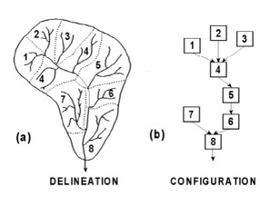
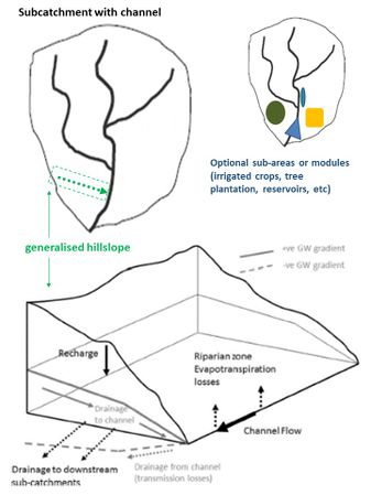
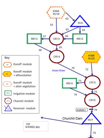
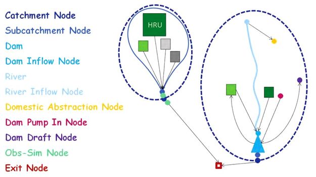
The schematic diagrams and tables below describe the main discretisation approaches used in each tool in terms of breaking up catchments into units and specifying linkages. For MIKE-SHE, because the tool offers many options, two generalised set-up approaches have been described (more background on these is given here).
| Level / Element | WRSM-Pitman
(Sami GW) |
SPATSIM-Pitman
(Hughes GW) |
ACRU4 | SWAT2012 | MIKE-SHE,
semi-distributed, more conceptual |
MIKE-SHE,
fully-distributed, more physical |
|---|---|---|---|---|---|---|
| Catchments
& subcatchments (subcats) |
WRSM catchments are composed of ‘modules’ linked in a user-specified network.
Module types:
Subcatchments are not explicitly input, but runoff modules and sets of linked modules act as subcats. |
SPATSIM catchments are composed of subcatchments. Subcats are linked in spatially determined flow network (map input). |
ACRU4 catchments are composed of subcatchments Subcats are linked in a user-specified flow network. |
SWAT catchments are composed of subcatchments
Subcats are linked in a spatially determined flow network (delineated by SWAT from DEM input, or given as a map input) |
MIKE catchments can be composed of subcatchments Subcats are linked in spatially determined flow network (map input). |
MIKE catchments can be composed of 3D grid units. The surface is uniformly sized grid cells. Each cell has a column beneath: input layers of soil, sediment, rock.
|
| Units within
subcatchments |
A WRSM ‘runoff module’ with no linked special areas functions as a subcat. If special area modules are linked, then a set of modules functions as a subcat.
Special area modules that can be added are:
These appear as separate units, but function as sub-areas inside a specified linked runoff module.
|
SPATSIM subcatchments all contain a river channel and may have specified special sub-areas. Subcats can optionally include either a wetland or a reservoir/lake on the channel at the subcat outlet.
A special sub-area can be defined for any, or all, of the following in a subcat:
Impervious, high ET cover, and irrigation areas do not have defined spatial locations within the subcat. |
ACRU4 subcatchments are composed of one or more HRUs. Non-headwater subcats must contain a river channel. Subcats can optionally include additional channels and reservoir units. Units are linked in a user-specified network.
There are special HRUs for:
For most HRUs, all runoff is routed directly to a channel, reservoir, or subcat outlet node (in parallel). Optional exceptions: For ‘riparian HRUs’, ‘baseflow’ output from other HRUs can be routed to the riparian HRU soil. For ‘adjunct-impervious HRUs’, runoff is routed to the surface of another HRU. |
SWAT subcatchments are composed of:
Subcats can include an internal pond or wetland and a reservoir/lake on the channel at the subcat outlet.
|
MIKE-SHE subcatchments are composed of:
Surface runoff is lumped for grid cells within an overland flow zone & routed across zones in a downslope series to the channel (potential for infiltration on route).
Interflow reservoirs receive percolation from overlying grid cells. Interflow is laterally routed through a downslope series of reservoirs to the channel (potential for loss to recharge on route). Baselfow reservoirs are recharged by overlying interflow reservoirs and outflow to the channel in parallel. |
Using fully distributed MIKE-SHE, no subcat boundaries are input. Relative water surface or head elevations on the surface and in the 3D grid units drives flow exchange between units.
Different sets of zone polygons can be used for the different types of properties (e.g. vegetation types, soil types, aquifer extents); they do not need to be aligned with one another. |
| River channels | WRSM channels are modules in the network with multiple inflow and outflow links possible.
Channel modules can have an associated wetland storage/area. |
SPATSIM channels are units linked to subcats (one per subcat).
They receive the local subcat runoff & upstream subcat channel outflows. |
ACRU4 channels are units in a subcat network of units. (necessary in non-headwater subcats).
They receive runoff from linked HRUs, reservoirs, & upstream subcat outflows. |
SWAT channels are units linked to subcats (one main channel per subcat).
They receive the local subcat runoff & upstream subcat channel outflows. |
MIKE channels are composed of spatially explicit reaches between node points. Reaches with nodes mapped inside a subcat exchange water with the subcat. | MIKE channels are composed of spatially explicit reaches between node points. Reaches can exchange water with grid cells that border them. |
Specific units & connections
Links between discretisation and process representation
The scale of discretisation of the landscape influences which hydrological processes are individually represented and the algorithms and the timesteps that are appropriate (discussed in more detail here). In general, for larger spatial/vertical units, longer timesteps, more lumped process representation, and different property parameters are applicable compared to modelling with smaller units. This has to do with how long it’s likely to take for water to move through a unit. For example, it may take a week for interflow to move through the 10 km long hillslope of subcatchment, but a day to move through the 1 km slope length of a patch of grassland within that subcatchment. Speeds vary by process. This also has to do with the fact that what we may model as one process at a larger spatial scale can be the result of several different processes occurring at smaller scales. For example, rain falling on a steep, rocky cliff may form surface runoff, but if this surface runoff then flows across an area of permeable and unsaturated soil before reaching a stream channel, some may infiltrate and not reach the stream as surface flow. If one models a subcatchment where this is happening as a single unit, the equation and parameters for estimating ‘surface runoff generation’ would account for the net outcome of surface runoff reaching the stream, i.e. the combined impact of the cliff and permeable toeslope on surface runoff reaching the channel. If modelling the cliff and the toeslope as separate units, surface runoff on the cliff unit could be calculated and then surface flow and infiltration on the toeslope unit could be calculated as a separate set of processes.
