Difference between revisions of "Main Page"
m |
m (→Background) |
||
| (4 intermediate revisions by the same user not shown) | |||
| Line 1: | Line 1: | ||
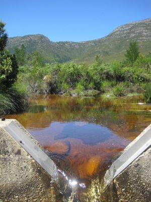
[[File:Kouga_weir_resize.JPG|alt=|thumb|Weir on the Wabooms River, Eastern Cape]] | [[File:Kouga_weir_resize.JPG|alt=|thumb|Weir on the Wabooms River, Eastern Cape]] | ||
| + | |||
| + | __NOTOC__ | ||
==='''<big>Welcome!</big>'''=== | ==='''<big>Welcome!</big>'''=== | ||
| Line 5: | Line 7: | ||
'''This wiki site was built to provide guidance for people working on hydrological modelling projects in South Africa, with a focus on catchment-scale modelling.''' | '''This wiki site was built to provide guidance for people working on hydrological modelling projects in South Africa, with a focus on catchment-scale modelling.''' | ||
| − | Catchment modelling entails ''a lot'' of decision-making, from deciding how many land cover types to include to deciding which modelling software tool to use | + | Catchment modelling entails ''a lot'' of decision-making, from deciding how many land cover types to include, or which rainfall datasets to use, to deciding which modelling software tool to use. This wiki aims to assist people in making informed decisions about model structure and using modelling software tools to achieve their intended catchment representation. The goal is to promote the ‘wise-use’ of modelling tools for the benefit of water resources management. |
| + | ==='''Scope'''=== | ||
The material assumes that users have a background in hydrology and exposure to modelling. ''You can find more details about the scope of this wiki [[Scope: what’s covered (and not!) in this wiki|here]].'' | The material assumes that users have a background in hydrology and exposure to modelling. ''You can find more details about the scope of this wiki [[Scope: what’s covered (and not!) in this wiki|here]].'' | ||
| Line 21: | Line 24: | ||
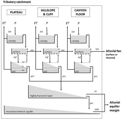
Modelling tools also change as new versions are released and new tools are constantly being developed. [[File:Conceptual_model_diagram_bucket_style.jpg|alt=|420x420px|thumb|Example conceptual model diagram (Glenday, 2015)|left]] | Modelling tools also change as new versions are released and new tools are constantly being developed. [[File:Conceptual_model_diagram_bucket_style.jpg|alt=|420x420px|thumb|Example conceptual model diagram (Glenday, 2015)|left]] | ||
| − | |||
| + | ==='''A wiki as a "living resource"'''=== | ||
| + | With your help this wiki site will adapt to the needs and developments in the South African modelling community. There are [[How to use "Discussion" pages|discussion pages]] associated with every content page where the user community can suggest updates. A moderator group will review and make content changes. | ||
| − | The idea for this site came from a group of early-career hydrologists facing many tricky modelling decisions in their research and projects. A salient challenge was selecting which modelling tool to use for a project. This decision has impacts on the structure of the model, what processes can be represented explicitly vs implicitly in the model, the kinds of input data and parameters that will be required, what outputs can be produced, etc. There weren't resources available that compared the structures and capabilities of different modelling tools available which included the South African developed tools, the Pitman model tools and ACRU, and were tailored to the South African context. In response, the Water Research Commission (WRC) funded the initial development of the material in this wiki through the “Critical catchment model inter-comparison and model use guidance development” project (2019-2021). More information and reports from that project are found [[Model inter-comparison study | + | ==='''Background'''=== |
| + | The idea for this site came from a group of early-career hydrologists facing many tricky modelling decisions in their research and projects. A salient challenge was selecting which modelling tool to use for a project. This decision has impacts on the structure of the model, what processes can be represented explicitly vs implicitly in the model, the kinds of input data and parameters that will be required, what outputs can be produced, etc. There weren't resources available that compared the structures and capabilities of different modelling tools available which included the South African developed tools, the Pitman model tools and ACRU, and were tailored to the South African context. In response, the Water Research Commission (WRC) funded the initial development of the material in this wiki through the “Critical catchment model inter-comparison and model use guidance development” project (2019-2021). More information and reports from that project are found [[Model inter-comparison study|here]]. | ||
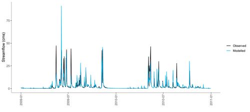
[[File:Modelled_vs_observed_flow_demo.jpg|alt=|500x500px|thumb|Modelled vs observed streamflow]] | [[File:Modelled_vs_observed_flow_demo.jpg|alt=|500x500px|thumb|Modelled vs observed streamflow]] | ||
| + | |||
| + | ==='''Need more help?'''=== | ||
| + | If you have modelling questions that you cannot resolve by consulting the modelling tool's manual or other resources, we recommend trying the question and answer platform [https://earthscience.stackexchange.com Stack Exchange, Earth Sciences subsite], to look for help (tag question with "hydrology" and "model"). If you have gained experience using a tool, consider using Stack Exchange to provide help to others so that the questions and answers become freely available to anyone online. Guidance on using this resource for hydrological modelling assistance can be found [[Stack Exchange Question & Answer platform |here]]. | ||
Latest revision as of 12:55, 23 November 2023
Welcome!
This wiki site was built to provide guidance for people working on hydrological modelling projects in South Africa, with a focus on catchment-scale modelling.
Catchment modelling entails a lot of decision-making, from deciding how many land cover types to include, or which rainfall datasets to use, to deciding which modelling software tool to use. This wiki aims to assist people in making informed decisions about model structure and using modelling software tools to achieve their intended catchment representation. The goal is to promote the ‘wise-use’ of modelling tools for the benefit of water resources management.
Scope
The material assumes that users have a background in hydrology and exposure to modelling. You can find more details about the scope of this wiki here.
This wiki focuses on several modelling tools that are commonly used in South Africa:
- WRSM-Pitman
- SPATSIM-Pitman
- ACRU4
- SWAT2012
- MIKE-SHE
These tools represent a variety of modelling approaches, however there are many tools out there with a wide variety of capabilities (see examples).
Modelling tools also change as new versions are released and new tools are constantly being developed.
A wiki as a "living resource"
With your help this wiki site will adapt to the needs and developments in the South African modelling community. There are discussion pages associated with every content page where the user community can suggest updates. A moderator group will review and make content changes.
Background
The idea for this site came from a group of early-career hydrologists facing many tricky modelling decisions in their research and projects. A salient challenge was selecting which modelling tool to use for a project. This decision has impacts on the structure of the model, what processes can be represented explicitly vs implicitly in the model, the kinds of input data and parameters that will be required, what outputs can be produced, etc. There weren't resources available that compared the structures and capabilities of different modelling tools available which included the South African developed tools, the Pitman model tools and ACRU, and were tailored to the South African context. In response, the Water Research Commission (WRC) funded the initial development of the material in this wiki through the “Critical catchment model inter-comparison and model use guidance development” project (2019-2021). More information and reports from that project are found here.
Need more help?
If you have modelling questions that you cannot resolve by consulting the modelling tool's manual or other resources, we recommend trying the question and answer platform Stack Exchange, Earth Sciences subsite, to look for help (tag question with "hydrology" and "model"). If you have gained experience using a tool, consider using Stack Exchange to provide help to others so that the questions and answers become freely available to anyone online. Guidance on using this resource for hydrological modelling assistance can be found here.


