Difference between revisions of "Wetlands"
Peni Metho (talk | contribs) |
Peni Metho (talk | contribs) |
||
| (2 intermediate revisions by the same user not shown) | |||
| Line 5: | Line 5: | ||
Using the national classification system of wetlands and other aquatic ecosystems in South Africa endorsed by SANBI (Ollis et al., 2013)<sup>[http://biodiversityadvisor.sanbi.org/wp-content/uploads/2016/07/Classification-system-for-wetlands-other-aquatic-ecosystems.pdf]</sup>, information about the physical wetland’s characteristics, hydrological processes and water movement, as well as its regulatory role on streamflow is available. The fourth level classification of wetlands as hydrogeomorphic units provides this information and has been used in other hydrological studies (Maherry et al., 2017<sup>[http://www.wrc.org.za/wp-content/uploads/mdocs/2191-1-16.pdf 2]</sup>; Tanner et al., 2019<sup>[http://www.wrc.org.za/wp-content/uploads/mdocs/2548_final.pdf 3]</sup>, Rivers-Moore et al., 2020<sup>[https://doi.org/10.3389/fenvs.2020.00058 4]</sup>). | Using the national classification system of wetlands and other aquatic ecosystems in South Africa endorsed by SANBI (Ollis et al., 2013)<sup>[http://biodiversityadvisor.sanbi.org/wp-content/uploads/2016/07/Classification-system-for-wetlands-other-aquatic-ecosystems.pdf]</sup>, information about the physical wetland’s characteristics, hydrological processes and water movement, as well as its regulatory role on streamflow is available. The fourth level classification of wetlands as hydrogeomorphic units provides this information and has been used in other hydrological studies (Maherry et al., 2017<sup>[http://www.wrc.org.za/wp-content/uploads/mdocs/2191-1-16.pdf 2]</sup>; Tanner et al., 2019<sup>[http://www.wrc.org.za/wp-content/uploads/mdocs/2548_final.pdf 3]</sup>, Rivers-Moore et al., 2020<sup>[https://doi.org/10.3389/fenvs.2020.00058 4]</sup>). | ||
| − | This information serves as a standard and comparable starting point for describing the physical wetland. If the situation allows, this information can be supplemented with | + | This information serves as a standard and comparable starting point for describing the physical wetland. If the situation allows, this information can be supplemented with data from local monitoring. |
| Line 39: | Line 39: | ||
All modelling tools except for SWAT conceptualise its simulated wetland as riparian wetlands. In the case of SWAT, a riparian wetland can be modelled using modified versions of SWAT available from independent researchers. | All modelling tools except for SWAT conceptualise its simulated wetland as riparian wetlands. In the case of SWAT, a riparian wetland can be modelled using modified versions of SWAT available from independent researchers. | ||
| − | As another example of modifying setups to infer a wetland type, Rahman et al. (2016)<sup> | + | As another example of modifying setups to infer a wetland type, Rahman et al. (2016)<sup>[https://doi.org/10.1016/j.envsoft.2016.07.003 5]</sup> developed a version of SWAT with riparian wetlands by changing the internal mechanisms of the model to allow the wetland to receive water from the river as opposed to the wetland only contributing water to the river. A summary of the wetland type preferences is presented below. |
{| class="wikitable" | {| class="wikitable" | ||
|+Type of wetlands in modelling tools | |+Type of wetlands in modelling tools | ||
| Line 151: | Line 151: | ||
|} | |} | ||
| − | <sup><small>a</small></sup> <small>ACRU4 has a riparian zone HRU which can be used as a wetland with direct subsurface and groundwater inflows; and bidirectional, horizontal groundwater interactions with the wetland storage '''( | + | <sup><small>a</small></sup> <small>ACRU4 has a riparian zone HRU which can be used as a wetland with direct subsurface and groundwater inflows; and bidirectional, horizontal groundwater interactions with the wetland storage '''('''''see'' riparian zones in [[applying tools in specific use cases]]''')'''</small> |
<sup><small>b</small></sup> <small>depends on wetland type: floodplains with subsurface storage will have bidirectional wetland-river interactions, floodplains with surface storage and lakes have unidirectional storage as water moves from the river into the wetland or from the wetland back into the river</small> | <sup><small>b</small></sup> <small>depends on wetland type: floodplains with subsurface storage will have bidirectional wetland-river interactions, floodplains with surface storage and lakes have unidirectional storage as water moves from the river into the wetland or from the wetland back into the river</small> | ||
| Line 174: | Line 174: | ||
'''<small>[4]</small>''' <small>Rivers-Moore, N. A., Kotze, D. C., Job, N., & Mohanlal, S. (2020). Prediction of Wetland Hydrogeomorphic Type Using Morphometrics and Landscape Characteristics. Frontiers in Environmental Science, 8, 58. https://doi.org/10.3389/fenvs.2020.00058</small> | '''<small>[4]</small>''' <small>Rivers-Moore, N. A., Kotze, D. C., Job, N., & Mohanlal, S. (2020). Prediction of Wetland Hydrogeomorphic Type Using Morphometrics and Landscape Characteristics. Frontiers in Environmental Science, 8, 58. https://doi.org/10.3389/fenvs.2020.00058</small> | ||
| − | <small>'''[5]'''</small> <small>Rahman, M. M., Thompson, J. R., & Flower, R. J. (2016). An enhanced SWAT wetland module to quantify hydraulic interactions between riparian depressional wetlands, rivers and aquifers. Environmental Modelling & Software, 84, 263-289. | + | <small>'''[5]'''</small> <small>Rahman, M. M., Thompson, J. R., & Flower, R. J. (2016). An enhanced SWAT wetland module to quantify hydraulic interactions between riparian depressional wetlands, rivers and aquifers. Environmental Modelling & Software, 84, 263-289. https://doi.org/10.1016/j.envsoft.2016.07.003.</small> |
<small>'''[6]'''</small> <small>Gray, R.P. (2011). Techniques for Assessing the Impacts of Wetlands on Hydrological Responses Under Varying Climatic Conditions. (Master's dissertation, Pietermaritzburg: University of KwaZulu-Natal). http://hdl.handle.net/10413/8076</small> | <small>'''[6]'''</small> <small>Gray, R.P. (2011). Techniques for Assessing the Impacts of Wetlands on Hydrological Responses Under Varying Climatic Conditions. (Master's dissertation, Pietermaritzburg: University of KwaZulu-Natal). http://hdl.handle.net/10413/8076</small> | ||
<small>'''[7]'''</small> <small>Yeo, I. Y., Lee, S., Lang, M. W., Yetemen, O., McCarty, G. W., Sadeghi, A. M., & Evenson, G. (2019). Mapping landscape-level hydrological connectivity of headwater wetlands to downstream waters: A catchment modelling approach-Part 2. Science of the Total Environment, 653, 1557-1570. https://doi.org/10.1016/j.scitotenv.2018.11.237</small> | <small>'''[7]'''</small> <small>Yeo, I. Y., Lee, S., Lang, M. W., Yetemen, O., McCarty, G. W., Sadeghi, A. M., & Evenson, G. (2019). Mapping landscape-level hydrological connectivity of headwater wetlands to downstream waters: A catchment modelling approach-Part 2. Science of the Total Environment, 653, 1557-1570. https://doi.org/10.1016/j.scitotenv.2018.11.237</small> | ||
Latest revision as of 08:11, 8 June 2021
Wetland representation
Estimating the level of wetland representation a modelling tool offers is a tool for reliably modelling a catchment with wetlands and the wetlands influence on the catchment hydrology. Wetland representation refers to how well a simulated wetland describes and includes the characteristics, processes, and function of a physical wetland. The representation is not binary but can be viewed as a scaled outcome of similarities and differences between the simulated and physical wetland. Assessments of wetland representation can be conceptual and quantitative.
Using the national classification system of wetlands and other aquatic ecosystems in South Africa endorsed by SANBI (Ollis et al., 2013)[1], information about the physical wetland’s characteristics, hydrological processes and water movement, as well as its regulatory role on streamflow is available. The fourth level classification of wetlands as hydrogeomorphic units provides this information and has been used in other hydrological studies (Maherry et al., 20172; Tanner et al., 20193, Rivers-Moore et al., 20204).
This information serves as a standard and comparable starting point for describing the physical wetland. If the situation allows, this information can be supplemented with data from local monitoring.
The criteria for assessing the suitability of a simulated wetland are based on how the modelling tool deviates from the standard definition of simulated wetland and other critical differences. At a very basic level, a simulated wetland is a depressional landscape that forms a water storage unit regulated by a water balance of temporally variable inflows and outflows (Rahman et al., 2016)5. The main, reoccurring differences from this definition occur through the following features in the simulated wetland concept:
- the type of wetland (based on the location relative to the river network – a riparian or geographically isolated wetland, GIW)
- the wetland’s dependence on the surrounding topography
- the inflows and outflows of the wetland water balance
- the type of storage (wetland storage conceptualised as a landmass or water body)
- the spatiotemporal scale of the storage
- the wetland’s interactions with the surrounding catchment
- the wetland’s interactions with the river and groundwater
These differences are distinguishing features of a modelling tool’s wetland. Other deviations arise from differences in the type of model (conceptual versus physics-based models or lumped versus semi- and fully-distributed models), how the model implements the wetland as a conceptual unit or a spatially explicit land unit, and the wetland geometry which affects the calculation of hydrological processes and the water storage in the wetland.
Type of wetland
Simulated wetlands in modelling tools used in the model inter-comparison project (see Wiki scope: Modelling software tools & versions covered for a list of the modelling tools) have basic premises on which the wetland concept is built.
- ACRU-4 conceptualises a simulated wetland as a depressional area with shallow water tables which become discharge zones for groundwater and surface water
- WRSM-Pitman conceptualises a simulated wetland as in- or off-channel storage systems
- SPATSIM-Pitman conceptualises a simulated wetland as a conceptual and large floodplain (temporally inundated wetland) or natural lake with one concentrated outlet; these simulated wetlands act as regulators of upstream river flows (i.e. surface water)
- SWAT conceptualises a simulated wetland as a conceptual open-water reservoir with varying inundation extents (i.e. changing area and water depths) and land cover conditions
- MIKE-SHE conceptualises a simulated wetland as an inundated flood zone
Each modelling tool can explicitly represent one type of wetland. In some modelling tools, the alternative wetland type can be implied by modifying the setup of the wetland unit in the catchment and how water is routed through the catchment.
For example, a simulated wetland in ACRU-4 was designed to represent riparian wetlands. However, GIWs can be represented by splitting one catchment into two subcatchments, with the upland subcatchment containing riparian wetlands to act as GIWs (Gray, 2011)6.
Water from the GIW is then routed to the downstream subcatchment.
All modelling tools except for SWAT conceptualise its simulated wetland as riparian wetlands. In the case of SWAT, a riparian wetland can be modelled using modified versions of SWAT available from independent researchers.
As another example of modifying setups to infer a wetland type, Rahman et al. (2016)5 developed a version of SWAT with riparian wetlands by changing the internal mechanisms of the model to allow the wetland to receive water from the river as opposed to the wetland only contributing water to the river. A summary of the wetland type preferences is presented below.
| Description | WRSM-Pitman | SPATSIM-Pitman | ACRU-4 | SWAT | MIKE-SHE |
|---|---|---|---|---|---|
| Wetland type | riparian | riparian | riparian | GIW | riparian |
| Dependence on topography | Yes | Yes | Yes | Yes | Yes |
| Ability to infer counter wetland type | Yes | Yes | No | No | Yes |
Alternatively, WRSM-Pitman as a conceptual, modular and parameterised model is equipped with the option to represent GIWs by indicating through a parameter that the wetland is an off-channel storage system.
While simulated wetlands consider the wetland type as an indicator of the wetland’s connection to the river, physical GIWs are not necessarily under the same restriction (GIWs can be functionally connected to the river network as reported in Yeo et al. (2019)7).
Wetland storage and water balance concept
There are two components to the wetland water balance concept: the storage and regulation of the storage with inflows and outflows.
The main differences in the wetland storage of simulated wetlands that differentiates the modelling tools include:
- the land cover characteristics (describing the wetland as a water body or land mass)
- the processes regulating the wetland storage (the mechanism for how the wetland is filled with and releases water, sometimes referred to as the spill-and-fill process)
- the spatiotemporal scale of the simulated wetland and storage calculations (the spatial scale of the wetland, its catchment unit in the context of the modelling tool and the rate or time step at which water levels are calculated)
The following table describes these wetland storage differences in the modelling tools compared.
| Description | WRSM-Pitman | SPATSIM-Pitman | ACRU-4 | SWAT | MIKE-SHE |
|---|---|---|---|---|---|
| Land cover type | open-water body | hybrid | land mass | open-water body | hybrid |
| Regulation process | threshold relationships between the main channel and wetland storage level and inflow rate | reproducing inundation hysteresis from threshold relationships and exponential functions between upstream river flows and the current wetland storage, the physiographic and hydraulic properties of the wetland | threshold processes, soil water budgeting and routing | water availability in the surrounding subcatchment | water level gradients between cells |
| Spatial scale | lumped module within a catchment | sub-model within a large subcatchment | HRU within a subcatchment | HRU within a subcatchment | grid cell |
| Temporal scale | monthly | monthly | daily | daily | daily |
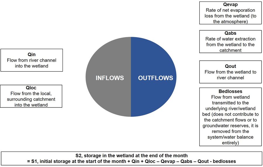
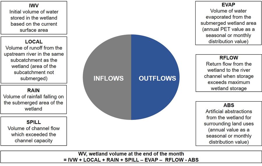
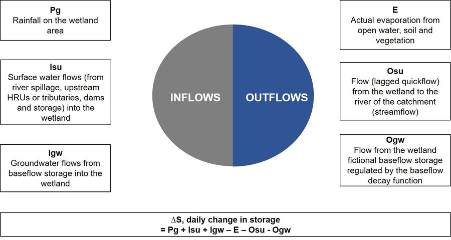
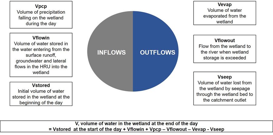
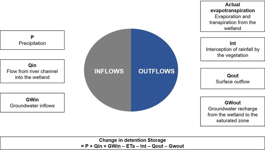
The inflows and outflows of a simulated wetland water balance are indicators of the water sources available to the wetland and that the wetland can contribute to.
An illustrative summary of the wetland water balances in each modelling tool is presented in Figure 1a-e. Most of the simulated wetlands receive surface water and rainfall as the main inflow with groundwater incorporated into the surface water flow pathway. ACRU and MIKE-SHE are the only tools with wetlands that have a separate inflow of groundwater. WRSM-Pitman and SWAT do not have direct groundwater outflows. In these tools, the wetlands contribution to groundwater is through baseflow and seepage losses, respectively. All modelling tools can account for water losses through evapotranspiration.
| Modelling tool | Water balance |
|---|---|
| WRSM-Pitman | |
| SPATSIM-Pitman | |
| ACRU | |
| SWAT | |
| MIKE-SHE |
Interactions controlling the wetland’s access to water
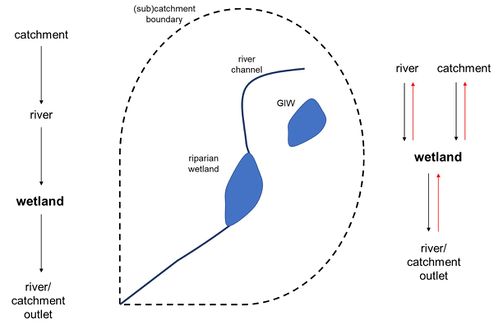
Similar to the wetland water balance, the interactions that the simulated wetland has with the surrounding catchment and between different components of the catchment controls the wetlands access to water. The interactions are either unidirectional (going in one direction and downstream only) or bidirectional (able to go back and forth between the source and destination of the water). Figure 2 illustrates this in terms of water routing between wetland and surface water. Uni- and bidirectional flows are depicted on the left and right, respectively.
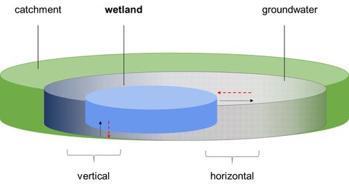
The wetland’s interactions with groundwater can be uni- or bidirectional as well vertical and horizontal. Figure 3 illustrates the potential water flow pathways. Vertically, water can move up or downwards between the water stored, soil, subsurface materials and groundwater reserves. Horizontally, water can move between the wetland and the surrounding land. The dashed red lines indicate water moving bidirectionally from and to the wetland.
Each modelling tool has a specific way of routing water to the river and uses the water flow pathways to capture the influence of the wetland on retaining and releasing water. The movement of water between water resources in the catchment and the wetland is tabulated in the main source of water and interactions of the wetland in the modelling tools.
The inflows into the wetland may include surface water, groundwater or a combination of these sources. Some wetlands receive groundwater directly from subsurface water or from groundwater while other simulated wetlands receive groundwater as a proportion of runoff and river flows. Interactions between the wetland and the catchment, surface water, groundwater and river are possible. The difference between wetland-surface water interactions and wetland-river interactions is that the former represents the channel inflow component in the water balance and is at the upstream end of the wetland while the latter refers to the interactions between the wetland and the river of the (sub)catchment (this could be at the downstream or upstream end of the wetland). Water losses from the wetland to groundwater, the surrounding catchment and the channel, another important water loss is through evapotranspiration.
| Description | WRSM-Pitman | SPATSIM-Pitman | ACRU-4 | SWAT | MIKE-SHE |
|---|---|---|---|---|---|
| Inflow source | combined | combined | separatea | combined | separate |
| Surface water | river runoff with baseflows | river runoff with baseflows | river runoff | land runoff with baseflows | river and/or land runoff |
| Groundwater | - | - | baseflow | - | baseflow |
| Interactions | |||||
| Wetland-catchment | unidirectional | bidirectional | unidirectional | unidirectional | bidirectional |
| Wetland-surface water | unidirectional | unidirectional | bidirectional | unidirectional | bidirectional |
| Wetland-groundwater | Unidirectional (horizontal only) | none | Unidirectional (vertical only)b | Unidirectional (horizontal only) | Bidirectional (both) |
| Wetland-river | unidirectional | bothc | bidirectional | unidirectional | bidirectional |
a ACRU4 has a riparian zone HRU which can be used as a wetland with direct subsurface and groundwater inflows; and bidirectional, horizontal groundwater interactions with the wetland storage (see riparian zones in applying tools in specific use cases)
b depends on wetland type: floodplains with subsurface storage will have bidirectional wetland-river interactions, floodplains with surface storage and lakes have unidirectional storage as water moves from the river into the wetland or from the wetland back into the river
c depends on wetland type and user-defined parameterisation
While it is not covered here, it is noteworthy to consider how the wetlands affect soil moisture and whether the wetland’s water can be made available for vegetation in the wetland and surrounding catchment. Restrictions on the vertical water movement between the wetland and groundwater should also be considered relative to the material underlying the wetland.
The final factor of wetland representation relates to the wetland as an integrated unit of the catchment (viz. the role of the wetlands on regulating streamflow). This requires assessing the streamflow output from each modelling tool.
References
This page presents material adapted from Metho, 2021, "A case study approach comparing wetland representation in hydrological models when estimating water availability for long-term averages, and short-term floods and droughts" MSc dissertation, UCT, supported (in-part) by the WRC project “Critical catchment model inter-comparison and model use guidance development” (2019-2021) (see Model inter-comparison study (2020-21))
Citations
[1] Ollis, D. J., Snaddon, C. D., Job, N. M., & Mbona, N. (2013). Hydrogeomorphic unit (Level 4). Chapter in Classification systems for wetlands and other aquatic ecosystems in South Africa. User manual: Inland systems. SANBI Biodiversity Series, 18-39. http://biodiversityadvisor.sanbi.org/wp-content/uploads/2016/07/Classification-system-for-wetlands-other-aquatic-ecosystems.pdf
[2] Maherry, A., Marneweck, G., Kapangaziwiri, E., Mandlazi, N.P., Hackman, J., Mwenge-Kahinda, J. (2017). Modelling of wetland processes impacting water resources at a catchment scale. Water Research Commission (WRC), Pretoria, RSA. WRC Report No. 2191/1/16. ISBN 978-4312-0822-7. http://www.wrc.org.za/wp-content/uploads/mdocs/2191-1-16.pdf
[3] Tanner, J.L., Smith, C., Ellery, W., Schlegel, P. (2019). Palmiet wetland sustainability: a hydrological perspective on system functioning. Water Research Commission (WRC), Pretoria, RSA. WRC Report No. 2548/1/18. ISBN 978-0-6392-0094-1. http://www.wrc.org.za/wp-content/uploads/mdocs/2548_final.pdf
[4] Rivers-Moore, N. A., Kotze, D. C., Job, N., & Mohanlal, S. (2020). Prediction of Wetland Hydrogeomorphic Type Using Morphometrics and Landscape Characteristics. Frontiers in Environmental Science, 8, 58. https://doi.org/10.3389/fenvs.2020.00058
[5] Rahman, M. M., Thompson, J. R., & Flower, R. J. (2016). An enhanced SWAT wetland module to quantify hydraulic interactions between riparian depressional wetlands, rivers and aquifers. Environmental Modelling & Software, 84, 263-289. https://doi.org/10.1016/j.envsoft.2016.07.003.
[6] Gray, R.P. (2011). Techniques for Assessing the Impacts of Wetlands on Hydrological Responses Under Varying Climatic Conditions. (Master's dissertation, Pietermaritzburg: University of KwaZulu-Natal). http://hdl.handle.net/10413/8076
[7] Yeo, I. Y., Lee, S., Lang, M. W., Yetemen, O., McCarty, G. W., Sadeghi, A. M., & Evenson, G. (2019). Mapping landscape-level hydrological connectivity of headwater wetlands to downstream waters: A catchment modelling approach-Part 2. Science of the Total Environment, 653, 1557-1570. https://doi.org/10.1016/j.scitotenv.2018.11.237
