|
|
| Line 24: |
Line 24: |
| | | | |
| | [[File:Modelled_vs_observed_flow_demo.jpg|alt=|500x500px|thumb|Modelled vs observed streamflow]] | | [[File:Modelled_vs_observed_flow_demo.jpg|alt=|500x500px|thumb|Modelled vs observed streamflow]] |
| − |
| |
| − |
| |
| − | {| class="wikitable"
| |
| − | ! Modelling tool !! Current curator / developer / owner !! Proprietary !! Time step !! Spatial discretization options* !! Documentation references
| |
| − | |-
| |
| − | | ACRU (Agricultural Catchment Research Unit model) || University of KwaZulu Natal (UKZN) Centre for Water Resources Research (CWRR) || no || Daily || Semi-distributed: HRUs (not catena) in subcatchments || (Schulze, 1986, 1995; Schulze and Davis, 2018)
| |
| − | |-
| |
| − | | FLEX- Topo || Delft University of Technology, Water Resources (TU-Deft) || no || Daily & sub-daily || Semi-distributed: HRUs (catena or not) in subcatchments || (Savenije, 2010)
| |
| − | |-
| |
| − | | HBV (Hydrologiska Byråns Vattenbalansavdelning) || Swedish Meteorological and Hydrological Institute (SMHI) || no || Daily & sub-daily || Lumped/semi-distributed: Subcatchment (zone option for snow & soil moisture) || (Bergström, 1976, 1995)
| |
| − | |-
| |
| − | | HEC-HMS + HEC-RAS (Hydrologic Engineering Center - Hydrologic Modelling System & River Analyses System) || US Army Corps of Engineers (USACE) || no || Daily & sub-daily || Semi-distributed: HRUs (not catena) in subcatchments || (USACE-HEC, 2000, 2010, 2018)
| |
| − | |-
| |
| − | | HPSF (Hydrological Simulation Program – FORTRAN) || U.S. Environmental Protection Agency (EPA) & U.S. Geological Survey (USGS) || no || Daily & sub-daily || Lumped/semi-distributed: Subcatchment OR HRUs in subcatchments || (Bicknell et al., 1993; Johanson et al., 1980)
| |
| − | |-
| |
| − | | HYPE (Hydrological Predictions for the Environment) || Swedish Meteorological and Hydrological Institute (SMHI) || no || Daily || Semi-distributed: HRUs (not catena) in subcatchments || (Arheimer et al., 2008; Lindström et al., 2010)
| |
| − | |-
| |
| − | | MIKE-SHE + MIKE-11 (Système Hydrologique Européen) || Danish Hydrologic Institute (DHI) || yes || Daily & sub-daily || Distributed/semi-distributed: Gridded OR HRUs (catena or not) in subcatchments || (Abbott et al., 1986; DHI, 2014; Refsgaard and Storm, 1995)
| |
| − | |-
| |
| − | | Pitman / WRSM-Pitman (Water Resources System Model) / SPATSIM-Pitman ( || Water Research Commission (WRC); SPATSIM: Rhodes University Institute of Water Resources (IWR) || no || Monthly (daily version exists) || Lumped/semi-distributed: Subcatchments (internal subdivision options: irrigated, IAP, wetland, impervious) || (Bailey and Pitman, 2015; Hughes, 2004, 2013; Pitman, 1973)
| |
| − | |-
| |
| − | | RHESSys (Regional Hydro-Ecological Simulation System) || University of California Santa Barbara, Bren School of Environmental Science & Management || no || Daily || Semi-distributed: HRUs (catena routing) in subcatchments (‘patches’ along ‘hillslopes’ in ‘basins’) || (Running and Coughlan, 1988; Tague and Band, 2004)
| |
| − | |-
| |
| − | | SWAT (Soil and Water Assessment Tool) || Texas A&M University & US Department of Agriculture (USDA-ARS) || no || Daily & sub-daily || Semi-distributed: HRUs (not catena) in subcatchments || (Arnold et al., 1998; Neitsch et al., 2011)
| |
| − | |-
| |
| − | | TOPMODEL || Lancaster University, Department of Environmental Science || no || Daily & sub-daily || Distributed: Gridded || (Beven and Kirkby, 1979)
| |
| − | |-
| |
| − | | VIC (Variable Infiltration Capacity model) || University of Washington, Department of Civil and Environmental Engineering || no || Daily & sub-daily || Distributed: Gridded || (Liang et al., 1994)
| |
| − | |-
| |
| − | | WEAP (Water Evaluation and Planning System) || Stockholm Environment Institute's U.S. Center || no || Month || Semi-distributed: HRUs (not catena) in subcatchments || (Sieber, 2019; Yates et al., 2005)
| |
| − | |-
| |
| − | | 3Di || 3Di Foundation (Delft University of Technology, Deltares, Nelen & Schuurmans consulting) || yes || Daily & sub-daily || Distributed: Gridded || (3Di Foundation 2015)
| |
| − | |}
| |
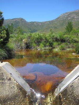
Weir on the Wabooms River, Eastern Cape
Welcome!
This wiki site was built to provide guidance for people working on hydrological modelling projects in South Africa, with a focus on catchment-scale modelling.
Catchment modelling entails a lot of decision-making, from deciding how many land cover types to include to deciding which modelling software tool to use for a project. The goal of this site is to assist people in making informed decisions about model structure and using modelling software tools to achieve this. It aims to promote the ‘wise-use’ of modelling tools for the benefit of water resources management. The material assumes that users have a background in hydrology and exposure to modelling. You can find more details about the scope of this wiki here.
This wiki focuses on several modelling tools that are commonly used in South Africa:
- WRSM-Pitman
- SPATSIM-Pitman
- ACRU
- SWAT
- MIKE-SHE
These tools represent a variety of modelling approaches, however there are many tools out there with a wide variety of capabilities (see examples). Modelling tools also change as new versions are released and new tools are constantly being developed.
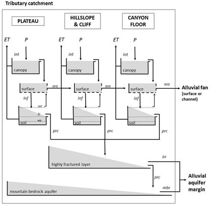
Example conceptual model diagram (Glenday, 2015)
This wiki is a living resource: With your help this wiki site will adapt to the needs and developments in the South African modelling community. There are discussion pages associated with every content page where the user community can suggest updates. A moderator group will review and make content changes.
The idea for this site came from a group of early-career hydrologists facing many tricky modelling decisions in their research and projects. A salient challenge was selecting which modelling tool to use for a project. This decision has impacts on the structure of the model, what processes can be represented explicitly vs implicitly in the model, the kinds of input data and parameters that will be required, what outputs can produced, etc. There weren't resources available that compared the structures and capabilities of different modelling tools available which included the South African developed tools, the Pitman model tools and ACRU, and were tailored to the South African context. In response, the Water Research Commission (WRC) funded the initial development of the material in this wiki through the “Critical catchment model inter-comparison and model use guidance development” project (2019-2021). More information and reports from that project are found here.
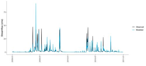
Modelled vs observed streamflow


